Tahiti
Positions
| Position Name | Shortcode | Callsign | Frequency | Login ID | Usage |
|---|---|---|---|---|---|
| Tahiti Oceanic | NTTT | Tahiti Control | 125.500 | NTTT_FSS | Primary |
| Tahiti Control | TAH | Tahiti Control | 134.700 | NTTC_CTR | Primary |
| Tahiti Approach | A-TAH | Tahiti Approach | 121.300 | NTAA_APP | Primary |
| Tahiti Tower | T-TAH | Tahiti Tower | 118.100 | NTAA_TWR | Primary |
| Tahiti Ground | G-TAH | Tahiti Ground | 121.900 | NTAA_GND | Secondary |
| Moorea Tower | TNTTM | Moorea Tower | 118.100 | NTTM_TWR | Primary |
| Bora Bora Tower | TNTTB | Bora Tower | 118.900 | NTTB_TWR | Primary |
| Raiatea Tower | TNTTR | Raiatea Tower | 118.500 | NTTR_TWR | Primary |
Tahiti
In the real-world, NTTT is operatated by the French, so there are some peculiarities in NTTT.
- Oceanic airspace (Class A) starts at FL195, instead of FL245 in NZZO.
- Outside of the Tower/Approach/Enroute CTAs, the NTTT FIR is Class E from FL045 to FL195. This means that -
- If you're flying IFR above FL045, you're required to grab an IFR clearance and separation from NTTT_FSS.
- If you're flying VFR above FL045, you're entitled to a traffic information service.
- If you're above FL045 within NTTT_CTR's 200nm arc, this service is provided by NTTT_CTR.
- Outside of the Tower/Approach/Enroute CTAs, and between SFC and FL045, you're flying in Class G.
Enroute
- NTTT_CTR: "Tahiti Control" on 134.700
- Provides a radar service within the Iles Sous Le Vent sector from 1500ft to FL195.
- Provices a procedural service outside of the Iles Sous Le Vent sector, up to 200nm DME TAF, from FL045 to F195.
- This 200nm diameter circle is Class E, where an IFR service is provided, and only a VFR traffic information service is provided.
- Provides an Enroute/Approach Control service for flights between NTTB (Bora Bora), NTTR (Raiatea), Huahine (NTTH) and Tupai (NTUU).
- NTTB and NTTR have their own Towers, operating from SFC to 1,500ft.
- NTTB_TWR also covers NTUU to the north.
- NTTB and NTTR have their own Towers, operating from SFC to 1,500ft.
- NTTH is uncontrolled, with the base of NTTT_CTR at 1,500ft.
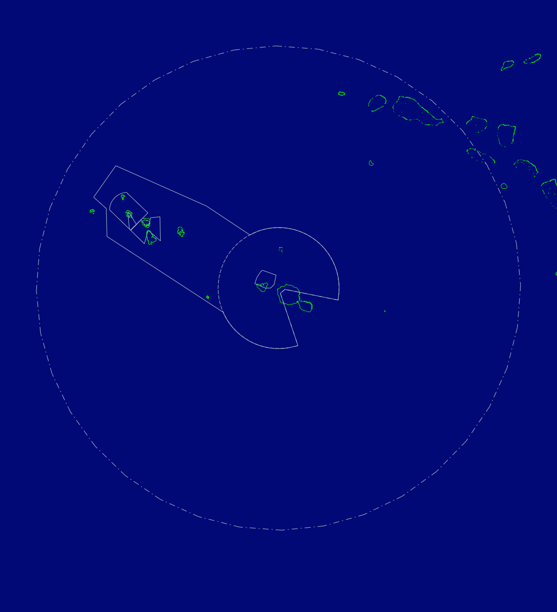
The outer-most ring is the 200nm ring. Inside of this, the Class E service is provided by NTTT_CTR - outside it is provided by NTTT_FSS.
TMA
- NTAA_APP: "Tahiti Approach" on 121.300
- A 50nm radius circle centered on NTAA, with a wedge missing from the SE due to the big ass mountain.
- Provides a service from 2,500ft to FL195.
Towers
- NTAA_TWR: "Tahiti Tower" on 118.100
- Limits: SFC to 2,500ft. Essentially a 20nm circle centered on TAF VOR, with two wedges cut out over mainland Tahiti and the island of Moorea.
- NTAA provides a ground service on 121.900.
- Moorea Tower (NTTM) is 10nm North West of NTAA, with a small control zone from SFC to 1,500ft. This zone sits inside of NTAA_TWR's airspace, and the Tower function is provided by NTAA when NTTM is off watch.
- NTTM_TWR: "Moorea Tower" on 118.700
- Limits: SFC to 1,500ft. Basically a square that sits over the North side of Moorea. Eastern lateral bound is roughly 5nm east of Moorea, and 10 miles to the North and West.
- The NTTM control zone sits entirely within NTAA_TWR's zone. When NTTM_TWR is off watch, the Tower function is provided by NTAA_TWR.
- The Approach service is still provided by NTAA_APP from 1,500ft. NTAA_APP does not perform top-down services to NTTM_TWR.
- Care needs to be taken surrounding the assignment of SIDs/STARs at Moorea, as the extended centerline for RWY 12/30 interfaces with RWY 04/22 at NTAA. Traffic at NTAA has priority.
- NTTB_TWR: "Bora Bora Tower" on 118.900
- Limits: SFC to 1,500ft. Bora Bora Tower's CTR is essentially a 15nm by 10nm box centered on BB NDB, with the long axis running NW to SE. There is a small wedge to the south of the AD, with the LL raised to 500ft.
- The Tower CTR sits within NTTT_CTR, and can expect the Approach and Enroute service to be provided by NTTT_CTR.
- TODO: Investigate behaviour between NTTB and NTUU, as NTUU sits within NTTB's CTR.
- NTTR_TWR: "Raiatea Tower" on 118.500
- Limits: SFC to 1,500ft. The Raiatea CTR is a weird bow-tie looking CTR, interfacing with Bora Bora's CTR to the NW, and extending out to the East by about 10nm. The top and bottom wedges are due to Fareura/Puurauti to the North, and Tefatoaiti to the South.
AFIS
About Flight Information Services
Flight Information Services provide a traffic advisory and weather information service. They also relay IFR clearances to aircraft on behalf of their senior sector.
These stations are not a priority, and are simply "nice to have" positions that would be cool to feature in an event.
- NTAR_FIS: "Rurutu Information" on 118.300
- NTAT_FIS: "Tubuai Information" on 118.300
- NTAV_FIS: "Raivavae Information" on 118.500
- NTGC_FIS: "Tikehau Information" on 119.500
- NTGF_FIS: "Fakarava Information" on 119.900
- NTGI_FIS: "Manihi Information" on 124.300
- NTGJ_FIS: "Totegegie Information" on 118.300
- NTGM_FIS: "Makemo Information" on 121.400
- NTGT_FIS: "Takapoto Information" on 118.500
- NTMD_FIS: "Nukuhiva Information" on 118.300
- NTMN_FIS: "Hiva Oa Information" on 119.700
- NTTG_FIS: "Rangiroa Information" on 118.300
- NTTH_FIS: "Huahine Information" on 119.300
- NTTO_FIS: "Hao Information" on 119.100
- NTTP_FIS: "Maupiti Information" on 118.300
- NTTR_FIS: "Raiatea Information" on 118.500